
New solution for designing and analysing air-source heat pump systems
In recent years, heat pump systems have become one of the most important technologies for decarbonising air conditioning systems In the new 2025 version, CYPE combines its solutions for the design and analysis of drinking water supply and wastewater and rainwater drainage systems into a single program The technology company reorganises its programs with the creation of new groups in order to improve efficiency and project management in an Open BIM workflow Wednesday, 5th juny. CYPE has...

Westchester County, NY selects GMV to provide Transit Technology Upgrade on 325 buses
The $16M contract and a new GMV office will establish a permanent footprint for the company in the New York Metro area LOS ANGELES, May 29, 2024 - Westchester County is home to a diverse population of more than 1 million people, with rail and bus connections into New York City. Following a competitive procurement, the County selected GMV to upgrade its transit technology platform to deliver more efficient service, better oversight of operations and improve the customer experience on Bee Line...

New Report: Engineers Have a Generational Opportunity to Harness AI for Good
Engineering Research Visioning Alliance’s (ERVA’s) latest report identifies a pathway for the U.S. to take the lead in AI Engineering. A new report released by the Engineering Research Visioning Alliance (ERVA), an initiative funded by the U.S. National Science Foundation (NSF), identifies key research directions needed to take advantage of the generational opportunity of “AI Engineering,” defined as the accelerating convergence of the artificial intelligence and engineering fields to deliver...

IMAGINiT Technologies Unveils Clarity 2025
IMAGINiT Technologies launched the latest version of Clarity, a task automation and analytics tool for Autodesk® Revit® and BIM 360® products. New features in the IMAGINiT Clarity 2025 release include integration with Oracle Aconex, enhanced functionality with Autodesk Revit Error Resolution, and advancements to the Clarity Space Programming Module. These updates improve project management efficiency and streamline workflows for firms on Engineering News Record’s Top 500 Design Firms list as wel...

Satellite-Based Sensors Provide Valuable Data for Pipeline Monitoring, Crop Production, and More
ISS National Lab Plays Key Role in Advancing Startup’s Sensor Technology KENNEDY SPACE CENTER (FL) – Using satellite-based hyperspectral sensors that can capture images of Earth beyond the visible light we can see with our eyes, startup Orbital Sidekick provides valuable global monitoring services to customers around the world. So far, the company has launched five commercial satellites, two of which went up in March, and has plans to launch a sixth later this year. Co-founder and CEO Dan...
Network Optix Partners with Curiosity Lab at Peachtree Corners to Launch Transportation Infrastructure Video Software for First Time in the U.S.
Award-winning Nx Go software, tailored for traffic infrastructure, deploys for the first time in a U.S. city in the heart of “Silicon Orchard” The smart city’s “IoT Control Room” – the first of its kind to be implemented in the county – features a wall of screens that integrates traffic camera feeds and data from LiDAR and more sensors installed across smart roadway infrastructure through Nx Go technology Peachtree Corners features 5G-connected infrastructure communicating with autonomous...

Esri Releases Latest Land Cover Map with Updated Sentinel-2 Satellite Data
Annual 10-Meter 2017–2023 High-Resolution Maps Available in Esri’s ArcGIS Living Atlas of the World REDLANDS, Calif. —Esri, the global leader in location intelligence, in its partnership with Impact Observatory, has released an updated global land-use/land-cover map of the world based on the most up-to-date 10-meter Sentinel-2 satellite data. In the update, the Sentinel-2 10m Land Use/Land Cover Time Series includes new data from 2023, expanding the series to include global coverage from 2017...
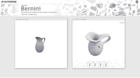
Autodesk Unveils Research Project Bernini for Generative AI 3D Shape Creation
Project Bernini is a research effort focused on developing generative AI for Design and Make industries. The first experimental Bernini model quickly generates functional 3D shapes from a variety of inputs including 2D images, text, voxels and point clouds. While Project Bernini is exciting and at the leading edge of generative AI, its models will become increasingly useful and compelling when trained on larger, higher-quality professional datasets. For the Design and Make industries, a...
Seyond Collaborates with Curiosity Lab and Peachtree Corners to Deploy LiDAR Solution to Improve VRU Safety and Traffic Intersection Efficiencies
PEACHTREE CORNERS, Ga. – Peachtree Corners – one of the United States’ first 5G smart cities powered by real-world connected infrastructure – announced a collaboration with global provider of image-grade LiDAR technology, Seyond. This collaboration enables Seyond to deploy and validate its LiDAR solutions in a real-world environment in an effort to create safer streets and smoother traffic flow for both vehicles and vulnerable road users (VRUs) in Peachtree Corners. Seyond’s LiDAR solution is...

Nalco Water launches Premium Cooling Water Program for enhanced reliability, performance and sustainability in power, energy, chemical and metal industries
NAPERVILLE, IL – Nalco Water, an Ecolab company, has launched the Premium Cooling Water Program to deliver outcome-based value that supports our customers’ key business drivers for the power, primary metals, energy and chemical processing industries. The program combines Nalco Water’s water management expertise with digital intelligence and new innovations in deposit sensing technology. The program also features advanced chemistry solutions, such as low-phosphorous and non-metal products, to hel...
Stormwater Interview with Robert Page, P.E., Vice President, HNTB

TriMet’s Banfield Type 1 Substation Replacement Project

February Issue 2026
