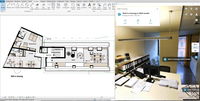
NavVis Launches Autodesk Revit Add-in
MUNICH, Germany – NavVis, a global leader in mobile indoor mapping, visualization, and navigation, announces a new add-in for Autodesk Revit. The add-in lets Revit users connect their BIM models to 360 degree immersive imagery and point clouds captured by the NavVis mobile mapping system. This add-in simplifies the process of creating and updating outdated BIM models to reflect the current state of the building. NavVis technology is an all-in-one reality capture solution that has made it pos...
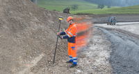
Leica Geosystems Introduces Latest GNSS Technology Smart Antenna for Construction
(Heerbrugg, Switzerland, 26 April 2018) – Leica Geosystems, industry leader in measurement technology, announced today the new Leica iCON gps 70 T smart antenna as part of its Leica iCON gps 70 series for reliable and easy stake-out jobs on any construction site. Measurement results become quicker and more accurate with the gps 70 T’s permanent tilt compensation, resistance to magnetic interferences and calibration-free usage. “The construction industry is one of the most hazardous workpla...

Bentley Systems Acquires Plaxis, and Complementary SoilVision, to Integrate Geotechnical Engineering within Digital Workflows for Infrastructure Projects
EXTON, Pa. – April 26, 2018 – Bentley Systems, Incorporated, a leading global provider of comprehensive software solutions for advancing infrastructure, today announced the acquisition of Plaxis, the leading provider of geotechnical software, based in Delft, Netherlands, and the agreement to acquire soil engineering software provider SoilVision, based in Saskatchewan, Canada. The acquisitions, with Bentley’s market-leading borehole reporting and data management software gINT, serve to make Bentl...
Mississippi DOT Aims for Technology Project to Ease Traffic Congestion in DeSoto County
The Mississippi Department of Transportation has begun providing motorists on a busy highway with estimated travel times on new dynamic message signs, in a technology-focused project that official hope will ease congestion on a route used by 40,000 vehicles a day. The department said the project – on east-west Goodman Road in DeSoto County in the state's northwest corner – installed traffic sensors and cameras on about 12 miles of highway from Olive Branch to Horn Lake, and the department sai...
Trimble to Acquire Viewpoint to Create the Industry’s Most Complete Construction Management Solution
SUNNYVALE, Calif.—Trimble (NASDAQ: TRMB) announced today it has entered into a definitive agreement to acquire privately-held Viewpoint from Bain Capital in an all-cash transaction valued at $1.2 billion. Viewpoint is highly complementary to Trimble’s e-Builder business, and will extend Trimble's ability to provide more complete and integrated project, jobsite and business workflows across the construction lifecycle. Viewpoint is a leading provider of scalable construction management software...

Trimble Acquires the Assets of FabSuite to Expand its Steel Fabrication Software Portfolio
SUNNYVALE, Calif.– Trimble (NASDAQ: TRMB) announced today that it has acquired the assets of Williamsburg, Virginia-based FabSuite, LLC, North America’s leading supplier of Management Information System (MIS) solutions for steel fabrication. With the acquisition of FabSuite software, Trimble’s portfolio now includes the complete structural steel workflow for planning, managing, designing, modeling and automating the fabrication processes to maximize constructability. Financial terms were not dis...
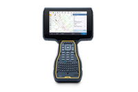
Trimble Announces New Field Solutions for Land and Construction Surveying
SUNNYVALE, Calif., — Trimble (NASDAQ:TRMB) announced today the Trimble® TSC7 Controller, a new field solution for land and civil construction surveyors. The TSC7, combined with specialized software, defines the next generation of data collection and computing for mobile workers. The Trimble TSC7 brings powerful enhancements to the field and was designed based on customer feedback. It provides a tablet experience with a physical keyboard and a sunlight readable 7-inch touchscreen that supports...
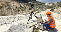
IDS GeoRadar Launches Compact Safety Monitoring Radar for Mining
(Pisa, Italy, 19 April 2018) – IDS GeoRadar, a leading provider of Ground Penetrating Radar (GPR) and interferometric solutions worldwide, today launched HYDRA-X, a radar-based technology solution specifically designed to support geotechnical engineers in the mining industry. HYDRA-X supports the different types of mine site needs, ranging from strip coal mines, tailing dams, small open pits, quarries and sub-benches monitoring in huge open pits. HYDRA-X is a compact radar solution that is ea...
What’s New in InfraWorks and Civil 3D 2019
InfraWorks roads imported to Civil 3D 2019 automatically generate as Civil 3D corridors. Autodesk recently announced the latest releases of Autodesk® InfraWorks® and Autodesk® Civil 3D® 2019. These software releases provide enhancements for closer collaboration, improved design, more efficient drawing production, tighter interoperability, and smoother data exchange. Below are the key enhancements for both products. InfraWorks Collaboration Enterprise cloud collaboration with BIM...
STRUCTUREPOINT Celebrates Tenth Anniversary
Skokie, IL —This year, StructurePoint is celebrating a decade of developing and supporting a suite of engineering software for the analysis and design of reinforced concrete buildings and bridges. Headquartered in Skokie, IL, the firm spun off from the Portland Cement Association (PCA) in 2007 to continue production of state-of-the-art engineering software originally developed by the PCA’s Engineering Software Group in 1957. “We are uniquely positioned to provide a set of focused tools for...
Stormwater Interview with Robert Page, P.E., Vice President, HNTB

TriMet’s Banfield Type 1 Substation Replacement Project

February Issue 2026
