
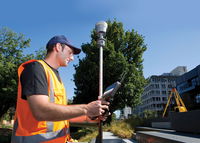
FARO® Introduces the ScanPlan™ Handheld Floor Mapper
Lake Mary, FL — FARO® (NASDAQ:FARO), the world’s most trusted source for 3D measurement and imaging solutions for public safety forensics and factory metrology, announces the availability of FARO® ScanPlan™ (www.faro.com/scanplan/sg), a solution for fast and easy mapping of floor plans. This next generation 2D handheld mapper is specifically designed to enhance the effectiveness of public safety professionals such as emergency responders, fire and crime scene investigators and security managers....
Software Tool Could Help Architects Design Efficient Buildings
Typically, when architects or engineers design a new building, it’s only at the end of the process — if ever — that a lifecycle analysis of the building’s environmental impact is carried out. And by then, it may be too late to make significant changes. Now, a faster and easier system for doing such analyses could change all that, making the analysis an integral part of the design process from the beginning. The new process, described in the journal Building and Environment in a paper by MIT r...
The City of Baton Rouge Selects a Smart City Solution from Hexagon to Connect its Operations and its People
NORCROSS, Ga. - The City of Baton Rouge has implemented a Smart City solution from Hexagon’s Geospatial division to connect their government operations and provide additional insights to help keep their city safe. This solution is built upon M.App Enterprise, which enables the city to create Hexagon Smart M.Apps to visualize and understand their most pressing problems. The City of Baton Rouge wanted a solution that would let them use their existing enterprise GIS data in its native format, bu...
Boral Resources Offers Sintered Light Weight Aggregate Production Technology
ATLANTA - Boral Resources has secured commercialization rights for the United States for a technology to manufacture ceramic light weight aggregate from high carbon ash. The resulting aggregate can be used in a variety of construction applications. High carbon ash generated from current coal-fueled electricity production, or recovered from landfills or ponds, can be used as feed material to manufacture the aggregate. Thus, in addition to producing a marketable product, the technology can help...
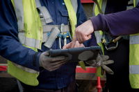
Hexagon Partners with Clevest to Improve Utility Field Operations
Huntsville, Alabama – Hexagon’s Safety & Infrastructure division and Clevest have partnered to offer Clevest’s workforce automation products alongside Hexagon’s utility GIS and outage management systems for integrated office-to-field solutions. The partnership expands the network engineering and operations offerings for utilities and telecommunications companies and smart cities in North America. Clevest provides software that connects the mobile workforce to office operations, optimizing fie...
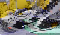
Video: Large-Scale 3D Printing by a Team of Mobile Robots
Roboticists at Nanyang Technological University in Singapore have, for the first time (as far as they know), performed “the actual printing of a single-piece concrete structure by two mobile robots operating concurrently.” Using a fleet of mobile robots for construction could have an extreme potential in other non-conventional aspects. One such application is to allow automated construction in hard-to-reach, remote areas, such as underground caves, the Moon or Mars, to which it is inconvenien...
Trimble Launches New Model of its R10 GNSS System for Land Surveyors
SUNNYVALE, Calif. —Trimble (NASDAQ: TRMB) today announced the launch of a new model of its premium Global Navigation Satellite System (GNSS) receiver, the Trimble® R10 Model 2 GNSS System. Designed to help surveyors in a wide range of industries work more effectively and productively, the Trimble R10 Model 2 enables reliable, fast and accurate collection of survey data in the field. The new enhancements include: The latest and most advanced custom Trimble survey GNSS ASIC with an industry-...

FARO® Announces SCENE 2018 with FARO Laser-HDR™ and High Detail Scanning
Lake Mary, FL— FARO® (NASDAQ:FARO), the world’s most trusted source for 3D measurement and imaging solutions for construction BIM, announces the release of SCENE 2018, a tightly integrated software platform specifically designed for the FARO Focus Laser Scanner product family. This introduction represents a substantial leap forward for 3D reality data capture and the FARO-driven concept known as Traceable Construction™, in which optimizing the entire AEC construction lifecycle is accounted for i...
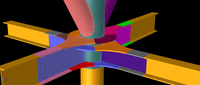
Bentley’s SACS Provides Advanced Analysis and Workflow Enhancements for Offshore Structures
Bentley Systems announces enhancements to its latest release of SACS CONNECT Edition, an offshore structural analysis application that offers fully automated and integrated 3D modeling, analysis and design to efficiently manage large, complex models for the evolving digitalization in the offshore market. This new release of SACS includes capabilities that help eliminate disjointed workflows and data, enhances interoperability with other applications, ensures safe structural performance during...
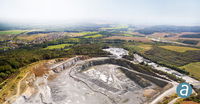
SimActive for Mining: Drones & Volume Calculation
Montreal, Canada – SimActive Inc., a world-leading developer of photogrammetry software, is proud to announce new features to improve volumetric calculation. Correlator3D™ now has integrated tools for users to generate precise statistics on mining activities. Applications like mineral extraction monitoring can all be done seamlessly within the software. Users can process raw drone data, produce point clouds and DSMs, and perform volumetric calculations, all in the same Correlator3D™ workflow...
Stormwater Interview with Robert Page, P.E., Vice President, HNTB

TriMet’s Banfield Type 1 Substation Replacement Project

February Issue 2026
