ULIS Launches ThermEye™ Building, a New Product Line Dedicated to Smart Building Applications
This thermal sensor line is for integrators needing detection and people counting capabilities for connected buildings ULIS will showcase ThermEye Building at IBS, Paris, November 6 – 7, 2018, at booth #E30 Grenoble, France – ULIS, a designer and manufacturer of a wide range of innovative thermal image sensors, today announces the launch of ThermEye Building, a thermal sensor line for system integrators of detection and people counting equipment for connected buildings. The ThermEye...

As Natural Disasters Increase Worldwide, Local Social Networks May be the Key to Preparedness, Says New Study Released Today
San Francisco, SOCAP - A new study released today found that being connected to your neighbors via a trusted social network during a natural disaster can save lives, decrease chances of injury and reduce economic loss. Can Mobile Phones Improve Disaster Preparedness? was independentl...

ProNovos Launches Operations-Focused Platform for Construction Biz
ATLANTA, Oct. 23, 2018 - Construction tech startup ProNovos today announced the launch of Operations Manager—software that ramps up contractors' profitability in groundbreaking ways. The cloud-based platform empowers contractors to track and manage bids, crews, equipment, punch lists, blueprints, requests for information and more in an easy-to-use interface. The software owes its origins to extensive contractor surveys conducted by Pronovos in 2017, said Bruce Orr, founder and Chief Data Scie...

New Open Applications Advance Comprehensive Modeling Environment for Multidiscipline Collaboration
LONDON, U.K. – The Year in Infrastructure 2018 Conference – Bentley Systems, Incorporated, the leading global provider of comprehensive software solutions for advancing the design, construction, and operations of infrastructure, today launched OpenSite Designer, a built-for-purpose application for the design and construction of civil site projects. It also launched OpenBuildings, bringing together its AECOsim building design and Speedikon factory and industrial design applications; and announce...

Dakota Micro Introduces HD Commercial Mobile Camera Systems to Improve Worksite Safety and Increase Productivity
FARGO, N.D.- North Dakota based manufacturer, Dakota Micro, Inc., announces their ruggedized, commercial rearview and surveillance AgCam and EnduraCam cameras and monitors are now available in high-definition (AHD). The high definition capabilities of the AHD AgCam and EnduraCam systems provide 4x the resolution of the most powerful analog cameras, resulting in clearer images even in dusty, wet or dark locations. Dakota Micro's new HD camera systems offer the same dependability and reliabi...
Bentley Systems Releases Open-Source Library: iModel.js
LONDON, U.K. – The Year in Infrastructure 2018 Conference – Bentley Systems, Incorporated, the leading global provider of comprehensive software solutions for advancing the design, construction, and operations of infrastructure, today announced the initial release of its iModel.js library, an open-source initiative to improve the accessibility, for both visualization and analytical visibility, of infrastructure digital twins. iModel.js can be used by developers and IT professionals to quickly an...
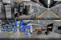
CoreSite Launches Concept3D's Virtual Tour Platform in Virginia Data Centers
DENVER - Concept3D, (https://concept3d.com) a leader in creating immersive online experiences with 3D modeling, virtual reality (VR), interactive maps and virtual tour software, today announced that CoreSite (https://www.coresite.com) has launched the Concept3D platform with a virtual tour of CoreSite’s state-of-the-art data center campus in Reston, Virginia. The Concept3D platform is an all-in-one software solution for data centers and other large facilities looking for an efficient and...

Leica Geosystems Increases Efficiency with Hydrographic Survey Systems Upgrade
(Heerbrugg, Switzerland – 18 October 2018) – Leica Geosystems, part of Hexagon, announced today the availability of Leica Chiroptera 4X and Leica HawkEye 4X. The latest upgrades introduce a new bathymetric LiDAR high resolution technology that increase the bathymetric point density by a factor four. The higher point density allows customers to deliver high resolution products at reduced operational costs. Flight cost savings of 50 per cent can be achieved for typical bathymetric LiDAR end use...

Leica Geosystems Introduces New Generation of Manual Total Stations
(Heerbrugg, Switzerland ) – Leica Geosystems, part of Hexagon, announced today the launch of the new manual total stations, the Leica FlexLine series. Building on the FlexLine series legacy of quality, durability and low total cost of ownership, the new Leica FlexLine TS03, TS07 and TS10 models are designed to improve productivity in the field by automatically capturing height. Replacing the former manual total stations (Leica FlexLine TS02, TS06, TS09 and Leica Viva TS11), the new series is...

BetterGIS Launches Its Powerful New Platform Nationwide, Offers Expanded Capabilities To Manage Utility And Facility Infrastructure
NOVATO, CA – October 17, 2018 – BetterGIS, formerly known as UndergroundGIS, today announced the nationwide availability of a newly enhanced platform that offers greater capabilities to manage utility and facility infrastructure. The expanded features in UVARA, the new name of the company’s cloud-based solution, provide owners, operators and third-parties with a streamlined, simplified GIS that maps a wide range of underground, surface and above ground assets, including pipes, lines, conduits...
Stormwater Interview with Robert Page, P.E., Vice President, HNTB

TriMet’s Banfield Type 1 Substation Replacement Project

February Issue 2026
