AGTEK Development Company introduces new software for materials takeoff, production control
AGTEK has introduced Materials, the next-generation software to simplify takeoff and production control of construction materials (Livermore, California, USA, 10 March 2020) – AGTEK Development Company, part of Hexagon, announced today the introduction of Materials, the next-generation software to simplify takeoff and production control of construction materials. The new software puts materials first and accounts for all construction cost items without entering any data twice. Users can ea...
SJI's Joist Girder Moment Connections Version 2.0 Now Available
The Steel Joist Institute (SJI) has released Version 2.0 of the Joist Girder Moment Connections. Release updates include: Updated to the AISC's 2016 specifications for most spreadsheets. Some HSS limit states maintained AISC's 2010 specifications, which gave the same results. Reference manuals have been revised to make them easier to follow. Spreadsheets have been updated with some corrections and to match each reference manual example. Each figure has been reviewed and modif...

ModelStream® 2.0 EAM Application Boasts Improved Performance and Integrated AI in Latest Version
New York, NY - Global BIM Management Consulting Firm Microdesk, a leading provider of business and technology services for the design and construction industry, has released ModelStream® 2.0, an Enterprise Asset Management (EAM) application that provides bi-directional synchronization of assets and location data between Autodesk Revit and IBM® Maximo®. The application alleviates the time and personnel resources needed to combine assets from IBM® Maximo® with the attributes and location data a...
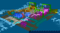
VRMesh V11.2 Adds Two-Sided Meshing for Visualizing Large-Volume Scans
Seattle, WA – VirtualGrid announced today the release of VRMesh v11.2, the latest version of its powerful point cloud and mesh processing software. This release presents a new method of point cloud meshing that enables users to convert point clouds to a two-sided mesh for visualizing intricate environments such as construction sites.As a technology pioneer in the field of point cloud meshing, VRMesh has been famous for creating an accurate mesh to represent original objects with high details. To...
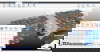
Gexcel announces RECONSTRUCTOR 4.2
Reconstructor 4.2 increases the capability to manage data from tunnels, underground and open-pit mines 3D surveys, thanks to new and improved tools that help users get the result done by a smart process. Gexcel has announced the release of Reconstructor that introduces some very interesting improvements for mining, tunneling, construction, and infrastructure applications thanks to new strategic workflows designed to easily guide customers to final deliverables from the surveying d...
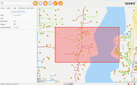
IQGeo Helps Peninsula Light Create Digital Twin of Electric Network
Cambridge – IQGeo (AIM: IQG), developer of mobile-first geospatial productivity and collaboration solutions for the telecoms and utility industries, is helping Peninsula Light to create a digital twin of its electric network and a new mobile meter deployment capability. IQGeo’s software has enabled Peninsula Light to digitize the rollout a major meter upgrade project that will see line crews and operational personnel using the IQGeo mobile software to install 33,000 new meters during 2020....

Polyglass Enhances ADESO Self-Adhered Membranes
Advanced self-adhered roofing membranes reduce installation time and labor cost DEERFIELD BEACH, FL— Polyglass U.S.A., Inc., a leading manufacturer of roofing and waterproofing systems, has enhanced the performance of its self-adhered mod bit roofing membranes. Used to design durable low-slope roof systems, the upgraded membranes install faster and cleaner resulting in labor and time savings. A pioneer of self-adhered roofing technology, Polyglass manufactures a full line of multi-surface...
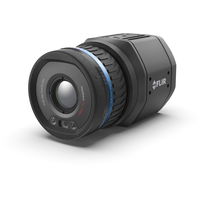
FLIR Launches its First Uncooled, Fixed-Mount, Connected Thermal Camera for Detecting Methane: GF77a
FLIR GF77a Offers Low-Cost Optical Gas Imaging Solution for Continuous and Autonomous Leak Detection ARLINGTON, Va.– FLIR Systems, Inc. (NASDAQ: FLIR) announced today the FLIR GF77a Gas Find IR camera, its first fixed-mount, uncooled, autonomous leak detection camera designed specifically to visualize methane and other industrial gases. A new camera in FLIR Systems’ optical gas imaging (OGI) series, the connected GF77a provides upstream and midstream gas processors, producers, and operators w...
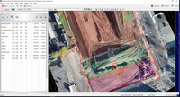
Virtual Surveyor Streamlines Volumetric Calculations for Stormwater Retention Ponds, Basins & Quarries
AARSCHOT, Belgium – Virtual Surveyor has released Version 7.1 of its popular drone surveying software, introducing functionality to efficiently calculate volumetrics in quarries, mine pits, retention ponds, and other basins that fill with water. This new functionality complements advanced cut-and-fill mapping capabilities unveiled in late 2019. “Virtual Surveyor is now the go-to package for managers of mines, drainage pits, and stormwater retention basins,” said Tom Op ‘t Eyndt, CEO of Virtua...

GeoBase Team Wins AFIMSC Team of the Year Award
The AFCEC GIO team is comprised of more than 50 geospatial professionals, most of whom work at Woolpert. JOINT BASE SAN ANTONIO-LACKLAND, Texas — The Air Force Civil Engineer Center (AFCEC) Geospatial Integration Office (GIO) GeoBase team was honored this month with the Air Force Installation and Mission Support Center (AFIMSC) Team of the Year Award. GeoBase is the U.S. Air Force Installation Geospatial Information and Services Program. The team comprises more than 50 geospatial professi...
Stormwater Interview with Robert Page, P.E., Vice President, HNTB

TriMet’s Banfield Type 1 Substation Replacement Project

February Issue 2026
