
Esri Announces Launch of ArcGIS Field Maps
REDLANDS, Calif.- Esri, the global leader in location intelligence, today announced the launch of the ArcGIS Field Maps mobile app. ArcGIS Field Maps is an all-in-one app that uses data-driven maps to help mobile workers collect and edit data, find information, plus report their real-time locations. ArcGIS Field Maps will solve many workflow challenges for organizations that have prioritized digital transformation from paper-based to digital field operations management. “In the past, someone...

SimActive Releases Version 8.6 of Correlator3D™
Montreal, Canada – SimActive Inc., a world-leading developer of photogrammetry software, announces the release of Correlator3D™ version 8.6. The new version includes multiple new features, such as the use of intensity data from LAS files for image registration, the ability to improve mosaic seamlines with a DSM and the support of DJI sun sensors. The software also now allows to handle single image satellite projects. Specifically, aerial triangulation can be performed using GCPs to improve...

Pix4D launches new ground image capture app for 3D modeling with the iPad Pro and iPhone 12 Pro
Lausanne, Switzerland, [November 10, 2020]: Pix4D, the photogrammetry industry leader, announces today the release of a new app product for ground images acquisition: Pix4Dcatch. Pix4Dcatch empowers users to easily create ground-based 3D models using an iOS mobile device. No need to be an expert, the user simply scans the area of interest with Pix4Dcatch. The app records pictures along with GPS positions. Compatible with recent iOS devices, but optimized for the newest iPad Pro and iPhone 12...
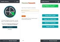
Thornton Tomasetti releases 'Healthy Reentry' free software to aid safe office return
Open Source App Provides Customizable Health Reporting And Contract Tracing Capabilities New York, NY – Thornton Tomasetti has open sourced its proprietary Healthy Reentry (HR) application for health monitoring and contract tracing. Designed to facilitate the safe return of employees to the workplace, the web-based solution can be customized to meet the needs of large and small companies while protecting the privacy of staff. Healthy Reentry enables employees to record their health s...

Dust detection and warning system tracks its first season
With its first monsoon season under its belt, data shows that ADOT’s innovative dust detection and warning system works as designed. Monsoon 2020, however, was not the most robust weather event, jokingly dubbed a ‘nonsoon.’ “It was a mixed blessing,” said David Locher, resident engineer for the project. “Less dust storms is obviously a good thing when it comes to driving conditions; however, we didn't have the normal weather events that would have been ideal for data gathering in our first...

Enscape Releases Version 2.9 With Vectorworks 2021 Integration
Milestone release adds Vectorworks to Enscape’s list of fully supported 3D modeling programs Columbia, MD (November 5, 2020)—Enscape GmbH, the leading provider of real-time rendering and virtual reality technology for the global architecture, engineering and construction (AEC) industry, has launched Enscape 2.9. This release supports Vectorworks 2021 from global design and BIM software provider Vectorworks, Inc. and allows architects, landscape design professionals and entertainment designer...

Leica Geosystems innovates automated total station portfolio
Range of automated total stations now with new integrated functionalities increase productivity in any environment (HEERBRUGG, Switzerland ) – Leica Geosystems, part of Hexagon, has enhanced the entire automated total stations portfolio in 2020. Starting with the new Leica Nova MS60 MultiStation and TS60 total station, now the new Leica TS16 and TS13 total stations and the new TM60 monitoring total station are introduced. Leica Geosystems’ automated total stations range is designed t...
Virtual Surveyor Introduces Curb & Gutter Mapping in New Version of Drone Surveying Software
AARSCHOT, Belgium – Virtual Surveyor has introduced Curb & Gutter mapping functionality in Version 7.6 of its popular drone surveying software. The new capability enables surveyors to create a lightweight CAD model of curbs and gutters along the edges of streets and parking lots from standard orthophotos and elevation models captured by unmanned aerial vehicles (UAVs), or drones. “Accurately mapping the height of curbs and geometry of gutters is critical for modeling the flow of water away fr...
Connected Vehicle Sensors Installed in East Hawaii
HILO – The Hawaii Department of Transportation (HDOT) is pleased to announce the installation of Blyncsy Intersect Connected Vehicle units on the 16 state-owned traffic signals in East Hawaii in cooperation with Elemental Excelerator. These connected vehicle sensors calculate travel times between units by anonymously collecting data from Bluetooth-enabled devices in passing vehicles. HDOT and the County of Hawaii will use data from the units to optimize traffic signal timing. Hawaii Island dr...

IntelliCAD Technology Consortium Announces Release of IntelliCAD® 10.0a
Portland, OR, USA — The IntelliCAD Technology Consortium (ITC) today announced the release of IntelliCAD 10.0a. IntelliCAD 10.0a is a maintenance release for version 10.0 that was previously issued on July 30, 2020. IntelliCAD maintenance releases concentrate on fixes, but IntelliCAD 10.0a includes minor new features: choose the color of print stamps, determine whether print stamps print upside down, and use the new Show Palettes and Hide Palettes commands. Also included for multiline text are...
Stormwater Interview with Robert Page, P.E., Vice President, HNTB

TriMet’s Banfield Type 1 Substation Replacement Project

February Issue 2026
