Surveying Is Fun and Data Is Cheap: Bentley Systems Sets Pace of Reality Capture
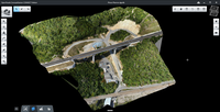
A 3D engineering-ready reality mesh created in ContextCapture comparing photogrammetry, LiDAR, and a hybrid input. Image courtesy of Bentley Systems and City of Strasbourg Surveyors are accustomed to working with sophisticated and powerful technology, such as GNSS, laser scanning, and photo capture, which makes their jobs so much easier than it used to be. Even 30 years ago, gathering geometric data about the real world used to be hard work, performed solely by well-trained experts. And, data...
78.7% of AEC Firms Expect Scanning/Modeling Work to Increase in the Next 12 Months
Washington D.C., August 9, 2016 — Despite swings in the global economic climate, strong growth is expected in the scanning and modeling market, as nearly 4 of 5 firms expect their business to expand in the next twelve months. This is just one of the critical findings in a new survey of the laser scanning and 3D modeling industry. Sent to over 5,500 firms, the survey illuminates crucial industry data including average project profit margin, scanning/modeling best practices, profit margin degrad...

Infrastructure Outlook: Key Points You Need to Know About Aerial Photography
By Sherry and Brett Eklund No matter the project at hand, knowledge is power. The more perspective an engineer can gain when planning or completing a job, the better. An aerial photographer, offering insights and data that can’t be gathered any other way, is an essential member of the team. Aerial photography provides an unmatched tool in evaluating a landscape before breaking ground, and it’s extremely helpful for assessing project milestones and reporting to offsite team members and ma...
Reality Computing Goes Underground with Ground Penetrating Radar
Ground penetrating radar (GPR) is a non-destructive method for locating and mapping underground objects by transmitting high-frequency radio signals into the ground that bounce back when they hit a buried object or a boundary between different material types. GPR surveys were first used in 1929 to measure the depth of a glacier in Austria and, in the following decades, likewise used to map the thickness of ice sheets and glaciers. In the 1970s, people started to use GPR for applications not invo...
Kindle Collaboration via LiDAR-Based 3-D Smart City Models
A smart city model allows many important stakeholders, including government officials, citizens and the private sector, to easily access critical infrastructure information. But most city departments, agencies and utilities have separate processes in place for long-term planning, updates and expansion as well as to support economic development–from permitting to call-before-you-dig to environmental programs and more. Each entity has different types of information that need to be available or...
Exploring Reality Computing for Civil Infrastructure
New Reality Computing technologies that capture the physical world digitally and deliver digital information physically are changing the design, production, and management of products or projects—from cars to factories to highways. Civil infrastructure projects are particularly well suited to Reality Computing, due to their size, scope, and inherent relationship to the physical world around them. In fact, aspects of Reality Computing are already used by many infrastructure design and constructio...

Technology-Enabled Organizational Efficiency with Greater Field-to-Office Connectivity
Higher efficiency and quality are equally needed across different industries. The global financial crisis has tightened its grip on professionals and organizations in almost all fields. As a result, several economic and environmental challenges are at play. Sprawling patterns of development, aging infrastructure and resource limitation are the symptoms of this global crisis. Governments and businesses alike strive to cut costs and maintain quality in light of resource limitations. Connecting...
Stormwater Interview with Robert Page, P.E., Vice President, HNTB

TriMet’s Banfield Type 1 Substation Replacement Project

February Issue 2026
