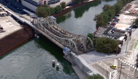
Video: Reimagine Bridge Inspection with Azure Remote Rendering and HoloLens
Discover how Bentley Systems enables remote bridge inspection with Azure Remote Rendering and #Microsoft HoloLens. Learn more about Azure Remote Rendering: https://www.aka.ms/remoterendering
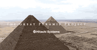
Video: High-Accuracy 3D Modeling Inside the Great Pyramid
Hitachi Systems and JEPICO partnered to capture and document the insides of the Great Pyramid of Giza in Egypt.

Video: Microsoft's Nancy Li Talks about Mixed Reality in Construction
At the Bentley Systems' 2018 Year In Infrastructure event held Oct. 15-18, 2018, in London, Todd Danielson, the editorial director of Informed Infrastructure, interviewed Nancy Li, Microsoft's global head of partnerships and industry solutions for its Mixed Reality and AI Perception Group.
HNTB Elevates Design with HD Aerial Imagery
Today's best proposals rely on fresh 2D & 3D aerial images. Communicate confidently and keep clients, stakeholders, and project managers on the same page. Watch this video to see how an engineering firm is enhancing design with current HD aerial maps.

Sponsored Content: You Have A Choice
Sponsored by: In the world of business and economics, a sunk cost is money that’s already spent and cannot be recovered. It’s a concept that’s said to stem from the oil industry, where the decision about whether to abandon an oil well is based on its expected cash flows, not on how much money was spent to drill it. In the oil well example, big decisions are black and white. But in other business, it’s not always so easy to see when it’s time to cut the ties that bind. For example...

Reality Modeling for Everyone
Highly Accurate Context from Simple Photography Before beginning any infrastructure project, a project team needs to survey existing conditions in order to provide the foundational input to the decision-making process—to understand the context within which the asset will be designed, built, and operated. The technologies and processes available to capture and visualize real world conditions have evolved beyond levels and tape measures to technologies such as Total Stations, aerial and ground-...

Creating Real-time Navigable 3D Infrastructure Models
Designing successful infrastructure projects is one thing. Communicating and demonstrating those designs to clients and other stakeholders before construction is another. Bringing a design to life for people without a civil engineering background is always a challenge, whether your goal is to sell the design or communicate its impact. Over the decades, civil engineers have used everything from elaborate hand drawings to carefully constructed physical models for this purpose. Then, in the 1990s...
New AVEVA Engage Redefines Engineering Decision Support
Dubai, UAE, Oct. 21, 2015—AVEVA today announced AVEVA Engage, a unique collaborative decision-support solution for capital projects and operating assets. It combines the power of instant access to a Digital Asset’s full contextually-integrated information with an impressively simple and entirely intuitive touch-driven interface, all visualised and navigable in a striking Ultra-High Definition (UHD) whole-model view. Part of AVEVA’s ‘Future of Decision Support’ programme, AVEVA Engage is bringing...
Managing the Model: “We Can Do It Faster the Old Way”
I've been hearing the title of this column, in one form or another, from engineering and architectural design firms for more than 20 years. I hear it from drafters, designers, engineers, architects, principals and owners, and it's usually in response to why they’re not using modeling software they often already own. I heard it when the industry was moving from hand drafting to CAD drafting. I heard it when CAD drafting was first beginning to be supplanted by attached object data, and basic mo...
Exploring Reality Computing for Civil Infrastructure
New Reality Computing technologies that capture the physical world digitally and deliver digital information physically are changing the design, production, and management of products or projects—from cars to factories to highways. Civil infrastructure projects are particularly well suited to Reality Computing, due to their size, scope, and inherent relationship to the physical world around them. In fact, aspects of Reality Computing are already used by many infrastructure design and constructio...
Stormwater Interview with Robert Page, P.E., Vice President, HNTB

TriMet’s Banfield Type 1 Substation Replacement Project

February Issue 2026
