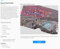
DroneDeploy Launches Drone Service Provider Directory to Help Businesses Ramp Drone Operations
SAN FRANCISCO, CA - DroneDeploy, the leading cloud-based drone software platform, today unveiled the Drone Mapping Directory, a drone mapping marketplace to connect businesses with drone service providers. At launch, the Drone Mapping Directory unites more than 250 drone service providers operating in 48 countries and servicing 10 industry verticals. DroneDeploy also announced the launch of a co-branded offering, which enables companies to brand their DroneDeploy portal and maps. The emerging...
Sedaru Deploys Smart CIP, Advancing the Connected Utility, Empowering Integrated, Dynamic Asset Management for Water/Wastewater Systems
/ / / / ARCADIA, Calif. - IDModeling, Inc. the leading global provider of smart water software and services, announced today the deployment of Smart CIP™ for integrated, dynamic asset management of water & wastewater systems. Sedaru's Smart CIP technology provides a lightweight, sophisticated, enjoyable-to-use platform for utilities to connect their data, experience, and institutional knowledge to quantify and prioritize capital improvement projects (CIPs) to consistently measure and increa...
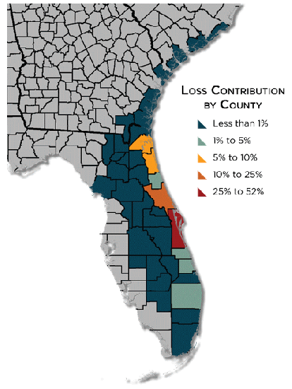
CoreLogic Analysis Shows Between $4 Billion and $6 Billion in Insured Property Loss from Hurricane Matthew
CoreLogic® (NYSE: CLGX), a leading global property information, analytics and data-enabled solutions provider, has conducted an analysis showing that insured property losses for both residential and commercial properties from Hurricane Matthew are estimated to be between $4 billion and $6 billion from wind and storm surge damage. This does not include insured losses related to additional flooding, business interruption or contents. Of this $4-6 billion, 90 percent of the insurance claims are exp...

TomTom’s HD Map Powers Autonomous Driving
MELBOURNE, Australia - ITS World Congress – TomTom (TOM2) today announces a joint autonomous driving demonstration with Bosch. TomTom provided its HD Map and RoadDNA technology to setup a demonstration on the Australian F1 Grand Prix circuit at Albert Park; these novel products are important components to enable Bosch’s demo vehicle to perform in autonomous driving mode. TomTom HD Map and RoadDNA are two revolutionary, highly accurate digital map based products helping automated vehicles precise...
Trimble Sells its Unmanned Aircraft System Business to Delair-Tech
SUNNYVALE, Calif. — Trimble (NASDAQ: TRMB) announced today that Delair-Tech has acquired its Belgium-based Gatewing Unmanned Aircraft System (UAS) engineering and manufacturing business. Delair-Tech is a leading provider of long-range, fixed-wing UAS solutions for industrial inspection and asset management applications headquartered in Toulouse, France. Delair-Tech intends to grow the acquired business as part of its portfolio. Financial terms were not disclosed. "This transaction is part of...

DJI and Datumate Partner to Deliver Site Survey Solution
DJI and Datumate have begun offering a drone, software and app package that fully automates and expedites site surveys. Tailored for professional surveying jobs, the DJI-Datumate Site Survey Solution simplifies the surveying and mapping processes, while maintaining superior accuracy. Shenzhen-based DJI is the world’s top aerial-imaging company. Israel based Datumate is a leader in automated “field-to-plan” surveying solutions. / DJI and Datumate Partner to Deliver Site Survey Solution /...
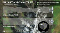
Teledyne Optech Announces New Efficiency Enhancement for ALTM Galaxy Wide-Area Lidar Mapping Sensor
Teledyne Optech is pleased to announce a high-performance scanner update to its innovative line of airborne laser terrain mappers, the Optech Galaxy ALTM™. The Galaxy’s scan efficiency has been engineered to deliver an additional 30% boost to its class-leading area coverage rates. When coupled with its innovative SwathTRAK™ and PulseTRAK™ technologies, collection efficiencies exceeding 70% are possible, relative to the traditional fixed-FOV dual-beam sensors currently on the market. According...
InterGEO2016: AltiGator and YellowScan Unveil a 5.6kg Survey-Grade LiDAR UAV all Integrated System, Ideal for Centimetric Urban Surveys
AltiGator and YellowScan are pleased to announce an ultra-light weight LiDAR UAV combo allowing for the first time centimetric UAV surveys in urban areas, in accordance with most regulations. The YellowScan Surveyor ultra-light stand-alone LiDAR system is embedded on the OnyxStar® XENA multirotor UAV, which is the last generation professional drone designed by Altigator. Compact, light, powerful and foldable, Xena is the result of the analysis of users' operational needs and months of Rese...

Idaho Transportation Department Director Brian Ness Named Finalist in Nationwide Navigator Awards Celebrating Innovative Spirit
BOISE - Recognizing an innovative spirit and a transformed culture that reflects a focus on the customer, the national organization Route Fifty has named Idaho Transportation Department (ITD) Director Brian Ness a finalist for the 2016 Navigator Awards in the “Agency and Department Chiefs” category. The winner from the 10 finalists in the category will be announced November 16 in Pittsburgh, Pennsylvania. Ness is a finalist in a category honoring “individuals across state, county and munic...

Dewberry's Gary Kirkbride Appointed to Northern Virginia Conservation Trust Board
Dewberry has announced the appointment of Gary Kirkbride as chairman of the Northern Virginia Conservation Trust Board (NVTC). The organization advocates for public land and appropriate land use. Additionally, NVTC offers advice and support to those interested in land conservation and proper land management. Kirkbride, an urban planner with Dewberry in the Fairfax, Virginia, office, has been involved with the NVTC for more than five years. Kirkbride has extensive experience in the supervis...
Stormwater Interview with Robert Page, P.E., Vice President, HNTB

TriMet’s Banfield Type 1 Substation Replacement Project

February Issue 2026
