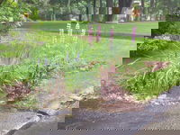
Don’t Lose Your LID—Learn These Lessons for Effective Stormwater Drainage
The concept of stormwater management under Low-Impact Development (LID) is fairly simple: it’s based on how nature handles rainfall in an undisturbed environment of meadows and woods. Nature works with simple concepts such as rainfall interception by the branches of a tree, which slows the velocity of a falling raindrop, which then lands on a soft bed of decaying organic matter on top of the soil. The organic layer further allows the rain to filter in and around the matter and then infiltrate in...
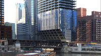
Tower of Power: Strong Steel Overcomes Constraints at a Tight Site
In Chicago, one of the world’s architectural capitals, it’s not uncommon to see unusual buildings, innovative designs and creative construction techniques. The winds are strong, the soil is poor, and there are a lot of regulations and coordination required to build. Overcoming the technical challenges associated with the unique design and construction of today’s highrises frequently is lauded by industry and the general public, as the buildings shed their boxy shapes and reach ever higher t...
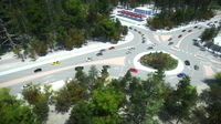
Washington State Department of Transportation Uses 3D Immersive Visualization
The Washington State Department of Transportation (WSDOT) Visual Engineering Resource Group (VERG) uses Bentley’s 3D immersive visualization software, LumenRT, to create images, videos, and real-time presentations for use in such diverse applications as design reviews, courtroom legal support, and cultural resource documentation. VERG has gained national recognition for producing visual communications that explain complicated stories to a mass audience in a compelling and engaging way. Solution...

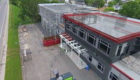
Reality Modeling for Everyone
Highly Accurate Context from Simple Photography Before beginning any infrastructure project, a project team needs to survey existing conditions in order to provide the foundational input to the decision-making process—to understand the context within which the asset will be designed, built, and operated. The technologies and processes available to capture and visualize real world conditions have evolved beyond levels and tape measures to technologies such as Total Stations, aerial and ground-...
Augmenting Drone Videos could Facilitate Construction Monitoring
Augmented reality is a fascinating technology that could change the way we live and interact with the world that surrounds us. Unfortunately, we don’t see many good applications of AR in engineering yet, partly because achieving good visual integration of digital objects with reality is very challenging. To display the augmented elements at the right location on a tablet display at every instant, the AR app must know the position of your tablet in real time - that is fundamental to AR. Now th...
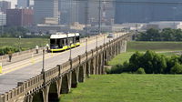
HDR Delivers Texas’ First Modern Streetcar System
The Union Station to Oak Cliff Dallas Streetcar TIGER Project is Texas’ first modern streetcar system. The project is a collaborative endeavor between the City of Dallas, North Central Texas Council of Governments (NCTCOG), Dallas Area Rapid Transit (DART) and the U.S. Federal Transit Authority (FTA). The 1.6 mile line received a USD 26 million Transportation Investment Generating Economic Recovery (TIGER) grant, separating itself from the other 17,000 TIGER grant applicants, due to its econom...

Creating Real-time Navigable 3D Infrastructure Models
Designing successful infrastructure projects is one thing. Communicating and demonstrating those designs to clients and other stakeholders before construction is another. Bringing a design to life for people without a civil engineering background is always a challenge, whether your goal is to sell the design or communicate its impact. Over the decades, civil engineers have used everything from elaborate hand drawings to carefully constructed physical models for this purpose. Then, in the 1990s...

Rethinking Rail Signal Design
Global consulting engineering firm Hatch Mott MacDonald had used a conventional CAD-based system to design rail signal systems when serving its public and private clients around the world. However, this approach had serious limitations in an industry where building information modeling (BIM), the processes and standards that define it, are becoming a critical success factor. Traditional methods mean designs have no added intelligence or connections to related documents including bills of mater...
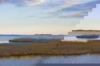
Wetlands Worth their Weight
Monitoring, Managing and Protecting Ecological Powerhouses “Wetland” is a generic term covering a wide variety of habitats that are wet for at least some period of time each year, have vegetation, and have soils that are saturated long enough during the growing season to produce oxygen-deficient conditions. Although they can vary tremendously depending on climate and topography, all wetlands promote the growth of different types of microbial, plant and animal communities. Wetlands attenuate...

Oxnard to Turn Alleys Into Amenities
The Oxnard Green Alleys Plan is a guidebook developed by the international landscaping firm SWA for the City of Oxnard to transform its underutilized alleys into amenities that provide multiple benefits to the community. The Oxnard Green Alleys Plan guides revitalization of Oxnard's alleys for providing bicycle and pedestrian connections, improving storm water quality, mitigating the urban heat island, creating open space for community recreation, and supporting local businesses. Challenge...
Stormwater Interview with Robert Page, P.E., Vice President, HNTB

TriMet’s Banfield Type 1 Substation Replacement Project

February Issue 2026
